This is a serious route of 53km / 33 miles leading into a remote glen. Suitable for mountain bikes. Some sections are on tarmac but long sections are on rough Land Rover tracks and at one point requires fording a river.
Ordnance Survey sheets 35 – Kingussie and Monadliath Mountains, 42 – Glen Garry and Loch Rannoch
Refreshments: Cafes and bars in Kingussie.
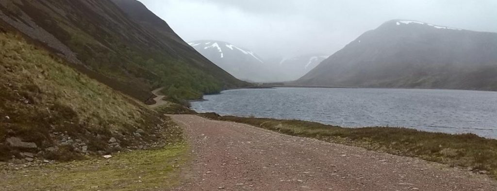
Start in Kingussie town centre and take the B970 quiet minor road past the Ruthven Barracks. After one and half miles take the grassy land-rover track which forks off to the right through a gate. Follow this track through moorland and trees along the west side of the river Tromie until you arrive at the keepers house for Glen Tromie Lodge. Cross the river by the bridge here and turn right on the land-rover track leading up the east side of the Tromie. The track then passes through a section of trees, past Lynaberack Lodge where the surface becomes tarmac and then crosses the river via a bridge. Always follow the main track, ignoring any side tracks to left or right. When the route reaches Tromie Dam the tarmaced road ends and the track becomes a well maintained Land Rover track. Pass Loch an t-Seilach and the Gaick Lodge where the track becomes more rough. Just after the lodge at a fork in the road turn right to cross the river again at a ford. Care will have to be taken here and if the river level is too high the route ends here. If the water is passable it is best to wade across rather than attempt to cycle. After passing Loch Bhrodainn on the right the track becomes steeper and reaches Loch an Duin, although this routes ends where the land rover track ends before quite reaching the loch. After a deserved rest, turn around and enjoy the much easier return back down Glen Tromie by the outbound route.
It is also possible to extend the route if there has not been too much recent rainfall via a track on the east side of Loch Duin. This joins another Land Rover track which leads eventually to Dalnacardoch Lodge. From here it is possible to join the Sustrans Route 7 running northwards leading back to Newtonmore and Kingussie.
Ability
Distance
Duration
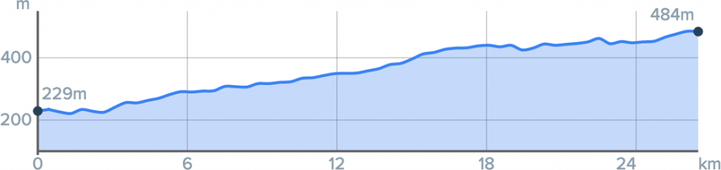
Ascent
Surface
Bikemaps.net